You can generate maps in QUANTA using two new tools on the X-AUTOFIT XBUILD main palette:
Map Options sets up the type of map to be calculated and the reflection file to be used. This is identical to the map calculation dialog from the CNX interface; note that the bottom three options should be ignored: always ask for the calculation to be immediate.
Calculate Map launches a series of calculations that result in a map being generated and displayed on screen.
Map management tools for defining the display of electron density maps are provided through the Maps Management table, making them available throughout all the functionality within QUANTA. This means that the maps functionality can be used at any time while using QUANTA, not just when carrying out crystallographic map fitting in X-AUTOFIT and X-BUILD.
The map management tools convert map formats to QUANTA-compatible brick maps and define active maps, contour levels and display styles. Additional tools save and retrieve the contents of brick map display lists and purge the brick map database of undisplayed bricks to reduce memory requirements.
The map calculation takes into account any changes in topology or conformation of the molecular system under study. The following checks are made:
If a map calculation is requested before any reflection data has been specified, you are prompted with the map options dialogue.
If only a conformation change has been made and a PSF of the same name exists, then no new PSF is generated.
If a configuration change (add / remove atoms) has occurred, or the molecular system has been re-selected from disk, a new PSF is generated.
To determine whether a PSF can be generated from the molecular system, it is a good idea to click Generate CNX PSF in the CNX interface first.
For example, the default atom typing in QUANTA is CHARMm atom types - when working with non-hydrogen proteins, the Engh and Huber are preferable. This can be changed within the CNX interface, or you can use the command: CHAR SET CHAR/ENGH.
The sequence of calculations is as follows:
1. Check whether a reflection file loaded; if not, ask for map options
2. Generate a PSF and parameter file, if needed
3. Create CNX input files (PDB, command file)
5. Convert the map to QUANTA bricked map format
6. If the map generated is not already loaded into QUANTA, a prompt for the contouring details appears.
7. The map is re-contoured according to the current Xfit settings
8. All files generated use the rootname of the first msf selected.
1. Open an MSF of a protein with no hydrogens.
2. Check that it is acceptable for CNX by testing whether a PSF can be generated. You can also change the host on which CNX runs.
3. Select Applications | X-AUTOFIT and click Calculate map.
4. Select the type of map and define the map extent.
5. Enter the grid size (0.25).
7. In the Identify reflection file and parameters dialog box, select the reflection file and specify the resolution range.
8. You are then prompted for the contouring options for the map before the map is generated.
9. Do some modelling. Then click Calculate map again to recalculate the map.
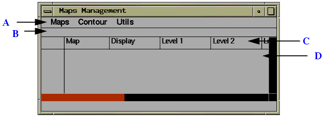
The Maps Management table provides an interface to the general-purpose volume visualization capabilities of the QUANTA program. 3D volume information is stored in brick maps in QUANTA. These brick maps are used for storing electron density, molecular probe maps, volumes, electrostatic potential, and molecular surface information generated within QUANTA. In addition, the maps can be generated by external programs for display within QUANTA. The molecular or volume properties that these maps contain are displayed within QUANTA as either chicken-wire contours or solid molecular surfaces.
The Maps Management table is available from within any application in QUANTA and provides a spreadsheet-like interface to the tools that manage and display the 3D information held in QUANTA brick map files. The display of the table is controlled by the function Map Table on the Draw menu.
These tools convert map formats to QUANTA-compatible brick maps and define active maps, contour levels and display styles. Additional tools save and retrieve the contents of brick map display lists and purge the brick map database of undisplayed bricks to reduce memory requirements.
The following figure shows the Maps Management table. The table has the following components:
The menu bar functions analogous to the menu bar of the main QUANTA molecule window. The menu items perform the following functions:
Imports external map formats and creates a QUANTA-compatible brick map file. Formats available from this interface are:
After you select a map type, a File Librarian is displayed from which you select the file you want to import.
Selecting Import Map spawns a process to run the program $HYD_MAP/mbkall in the QUANTA software. The source for this program is available for user modification in the $HYD_MAP directory.
Displays a File Librarian listing all available files with an.mbk extension. A QUANTA brick map file can be selected and displayed even if it was previously selected. This option is useful for displaying the map with more than one display style.
When a file is selected, the file header is displayed in the textport and the Define Contour Levels and Characteristics dialog box appears. In this box, you can specify one to six contour levels, line style and thickness, and the value and color of each contour level. For information on this dialog box see the Set Contour Levels section.
Deletes a map from the active list and deletes all bricks generated from this map both from the display list and the brick map database. If only one map is in use, that map is automatically deleted. If more than one map is in use, a scrolling list appears permitting you to select the map to be deleted.
If more than one map is in use, a File Librarian is displayed from which you select a map to replace the deleted one.
In the textport, lists the active brick map files. The listing includes the following information:
Hides the table. The table can be redisplayed by selecting the Show Map Table from the top-level View menu.
Contours the map at the currently specified contour levels for the currently displayed atoms in the viewing area.
Contours the entire brick map at the currently specified contour levels. Contouring can be interrupted at any time by clicking the mouse button. This is useful if you select this option by mistake for a large map.
Displays the following dialog box for entering the dimension of a cube as illustrated. After you specify this value and click OK, the brick map is displayed as a cube with the specified dimensions.
Controls preservation of currently displayed bricks when a new set of bricks is calculated. You can choose whether the current selection of bricks is cleared and replaced when a new selection is specified or whether subsequent bricks are added to the current selection.
The Define Contour Levels and Characteristics dialog box is used to change map specifications for currently defined maps. If more than one map is in use, a scrolling list of current maps is displayed from which to select one.
The number of currently defined contour levels can be changed in this dialog box. If the contour levels are changed for currently displayed bricks, the displayed bricks are deleted from memory and the brick map database.
Sets the thickness of the contour lines in pixels. The default is zero. System limitations prohibit setting line thickness greater than 1 for anti-aliased lines for some graphics boards.
Sets the line type to solid, dotted, dashed, or dot-dash. The default is solid. When anti-aliasing is on in QUANTA, all non-solid line styles are displayed as solid lines.
Toggles the display of the entire map. If this option is off, contours for newly selected bricks are not displayed.
Characteristics of Density in Map
Displays the current minimum and maximum densities and the sigma value for each map. These values are not editable. The sigma values aids in assigning contour levels.
Determines whether a contour is calculated. As many as six contours can be calculated per map regardless of its display status. By default, two levels are calculated.
Specifies whether the individual contour level is to be displayed initially. Each contour can be displayed in a different color.
Displays the value for a calculated contour.
Defines the color to be used for the contour level. Any of display colors 1 through 14 can be entered.
Accepts changes and exits the dialog box.
Automatically sets the level of included contours to values distributed between the minimum and maximum values of the map. This selection only affects contours that are included. Several contours should be marked as included before you choose this selection.
Automatically sets the level of included contours to values starting at zero and incrementing in steps of sigma. If the sigma value of the map has not been calculated or is set to zero, this option does not work. Several contours should be marked as included before you select this option.
Exits the dialog box with no changes.
Displays a dialog box in which the parameters used to select the bricks of density to be displayed are set.
Is an additional radius added to the coordinates of atoms when selecting bricks on the basis of the currently displayed display.
Toggle can be used to control the option to delete portions of the data within a brick of density that are beyond a certain distance from any atom. This can be used to remove extraneous density that is more than the Cover Radius from an atom. This mask map option should be used with great caution, since it may remove the display of pieces of density that indicate that the model may need further refinement or rebuilding.
Controls whether progress-monitoring messages are displayed in the textport when maps are being contoured for display.
Deletes all undisplayed contoured bricks in system memory. This tool is useful if many large maps are contoured, and the system's resources for graphical object management are depleted. Other objects that may compete for these system resources are dynamics trajectories and dot surfaces. Tools to remove these objects from memory are found in the associated applications.
Resets the map contour line width and style for all maps to 0.
Shows the coordinates and contents of the currently selected cell in the Maps Management table. The contour level values can be edited here - this is a shortcut that removes the need to enter the Set Contour Levels dialog box. Once changed, the contours corresponding to the previous contour level are deleted. The map can then be recontoured using other QUANTA commands, such as Contour Maps.
This row of the table contains the headings for each column of the table. The following table explains what each column contains and what action follows selection of the heading:
Each map selected for display in QUANTA is represented with a different line. A maximum of six maps can be selected.
Each cell in a row contains information about the map or contour level displayed. Picking each cell performs a particular task, as described in the table below:
Picking this lists all available information about that map to the textport. |
|
Displays the Define Contour Levels and Characteristics dialog box (see Set Contour Levels) |
|
Toggles the display of the contours for that map on (yes) or off (no). |
|
Picking a level toggles its display on and off and selects that cell for possible editing in the edit line of the table. |
|
Increments this map's contour line width by 1, up to the maximum (set with the SET LINE MAX command), and then back to 1. |
|
Increments the line style for the contours of this map in the sequence 0, 1, 2, 0. etc. |
The control of maps in QUANTA is available in all parts of QUANTA.
Some tools available in the Map palette and the Maps Management table are not relevant within X-LIGAND, X-SOLVATE, X-AUTOFIT, X-POWERFIT, and X-BUILD. These applications automatically control the map display; so changes to some general map options can interfere directly with the tools' use of the maps, with serious detriment to speed and results produced. These include:
Do not use Map palette or Maps Management table commands.
No commands from the Map palette or Maps Management table should be used while within these applications. These applications are entirely automated and control all map functionality directly. Open all maps before entering these applications.
Do not use the commands found under Map | Contouring options or Maps Management table | Contour | Options while in X-AUTOFIT: X-BUILD.
These applications check the status of the open maps before every command, so all the Map palette or Maps Management table commands can be used with these applications. In particular, opening, closing, and changing contour levels is important for use of X-AUTOFIT and X-BUILD.
The map options that should not be used while in X-AUTOFIT and X-BUILD are those that affect how the map is actually contoured. This is because X-AUTOFIT and X-BUILD use a streamlined process of map contouring where a box of density is automatically generated around the working position, and the only change allowed is to the radial size of this box. This is controlled under X-AUTOFIT: X-BUILD | Options | Map radius.
The use of the following commands is strongly discouraged. In particular the identical commands found under Map | Contouring options or Maps Management table | Contour | Options must not be used while in X-AUTOFIT:X-BUILD because:
1. Small values of Cover radius produce false contours (especially for difference density) and result in incorrect bones and incorrect solutions to real-space refinements.
2. These commands significantly slow down the contouring process, because contouring by algorithm is more complex than simple contouring.
3. These commands do not work if no coordinates are present.
4. These commands may produce other unwanted side effects.
The following table shows which contouring options can or cannot safely be used in X-AUTOFIT:X-BUILD: